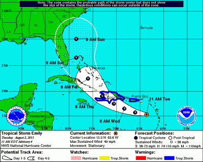
Actually, so far Tropical Storm Emily doesn’t seem like a big deal for South Florida:
DATA FROM A RECONNAISSANCE PLANE INDICATE THAT EMILY REMAINS POORLY ORGANIZED. THE MINIMUM PRESSURE IS AROUND 1007 MB… AND WINDS ARE LIGHT OR VARIABLE ON THE SOUTH SIDE. THE INITIAL INTENSITY IS KEPT AT 35 KNOTS. THE ENVIRONMENT IS NOT IDEAL FOR STRENGTHENING SINCE THERE IS SOME DRY AIR TO THE NORTH AND WEST OF THE STORM…BUT THE OFFICIAL FORECAST CALLS FOR A SLIGHT INTENSIFICATION AS SUGGESTED BY THE SHIPS…GFDL AND HWRF MODELS. IT IS INTERESTING TO NOTE THAT THE RELIABLE GFS AND ECMWF GLOBAL MODELS NO LONGER DEVELOP EMILY…AND IN FACT…BOTH MODELS BASICALLY DISSIPATE THE CYCLONE NEAR HISPANIOLA.
In any case, around here Tropical Storm force winds tend not do much more than rough up the vegetation a bit, although it’s not something you want to be out driving in. But I do think we’re in for a busy season of weather-with-a-name — there wasn’t any report of African dust in the air this summer, and I’m coming to think that it’s the dust that has kept hurricane activity tame the last few years.

Perhaps the winds are not that bad, but the rain can be horrible. Fay dumped around 26 inches on Brevard County in less than two days.